

Arctic à la Covid - Gates of the Arctic National Park - June 2020
Like literally every person on the planet, my 2020 has not gone as planned. I don’t know if you’ve heard, but there is a global pandemic. It has interrupted some things.

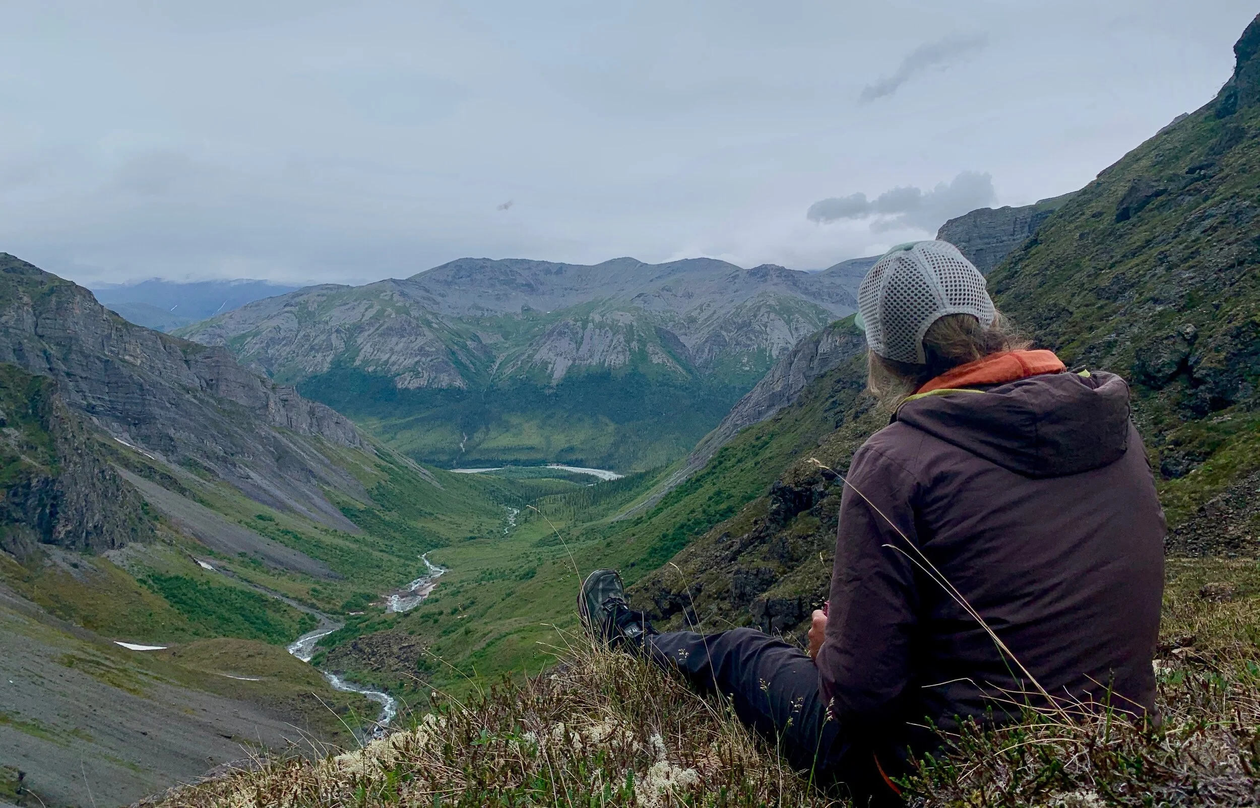
Jaime Welfelt hikes above the North Fork of the Koyukuk River, Gates of the Arctic National Park, June 2020
First and foremost, I’m so grateful to be housed, adaptable, employed, healthy and happy. Since most of you reading this are outside of the state of Alaska (thank you analytics) I’m happy to report that very few Alaskans have died of COVID-19. Our state is insulated against this pandemic by our geography and early, proactive restrictions on entry. But we’re also vulnerable to it due to our limited (urban) to nonexistent (rural) hospital resources. As I write this in July, cases are spiking in Anchorage and some rural regions are seeing their first cases, so I’m afraid the worst may be yet to come for Alaska.
When the reality of the pandemic became clear, my existing plans to visit the Brooks Range, some of which involved travel through villages, changed. Getting to meet people who live in rural Alaska - and know these landscapes better than anyone - is often a highlight of my trips. But this year, many villages took the initiative of shutting down visitation by outsiders, others chose not to or were unable to restrict access. Regardless of regulations, by April/May it was obvious that visiting rural Alaska unnecessarily would be both reckless and inconsiderate. But adaptability is one of the great lessons you learn from executing big trips in Alaska; always have a plan-B.
So, in this very weird year, a road-to-road option become the best course of action. And there is so much to do from “the road” - aka the Dalton Highway. So many of the commercially guided and independent trips to the Arctic fly deep into the backcountry, but honestly if you put only one ridge or mountain between you and the road, it feels as wild as any place. This was my fourth trip in the Brooks Range that started or end or both at the Dalton Highway and these trips have been every bit as satisfying as those that utilized air travel. Plus, as I’ve written about before, I’m excited about going on more low-carbon adventures.

Blowing up our packrafts at 7pm (notice all that good arctic light!) to cross the Dietrich River and get this show on the road!
A plan was hatched with some friends whose typically busy summers of field work and guiding were uncharacteristically quiet due to the coronavirus. Two of our party would start the trip with us and then head back on an abbreviated route/itinerary and two of us would continue on a loop that took us west to the North Fork of the Koyukuk River, down the North Fork in packrafts and then back to the road at the town of Coldfoot. The four of us drove north from Fairbanks to the edge of the Dietrich River near its confluence with Kuyuktuvuk Creek. We parked my truck at 6pm and I made a silent plea to the universe that neither bear nor human nor porcupine would destroy her while she sat for 8 days. We crossed the Dietrich and headed west a couple of miles before calling it a night.

Spruce trees giving way to Alpine tundra. Heading for the top of Trembley Creek.
From there we had four days of walking, two days of boating and another two days to return to the road. Our first full day began with a few miles of tromping right up Trembley Creek. Fortunately, water was low so we were able to pin-ball back and forth from one gravel bar to another. At times we walked directly up the creek. Honestly, on a hot day in the Arctic, nothing feels better than overtopping my boots and wading in a frigid creek. Half-way up Trembley we accessed the alpine - tundra spread out before us, the spruce trees diminished and then disappeared. We camped between Eekayruk and Falsoole Mountain, in a breezy wildflower meadow and it felt like we were really in the Brooks Range.
The next day, my trip partner Jaime and I waved good bye to our friends and continued on to cross a series of undulating tundra passes which were classic, easy-miles tundra walking. Late in the day, as we were headed for an alpine lake where we intended to camp, we stopped in our tracks as three dark shapes lopped across the tundra in front of us. Our first thought was bear, but we quickly realized we were seeing three adult wolverines! They disappeared from sight, but we quickly crossed a steep drainage that separated us and caught sight of them again. All three were together, oblivious to our presence and engaged in some type of behavior we could not figure out - maybe they were digging, or pulling on something, we just were not sure. Oddly, it looked like they were curled in on themselves in little balls. After thirty minutes of watching them, we slowly started to circle wide around them towards our intended campsite. They caught wind of us and one at a time started moving away, with varying degrees of alacrity and curiosity. When they had all moved on, we went and investigated where they had been and discovered piles of downy hair. Turns out they were grooming themselves, pulling out their undercoats!
So far, Jaime and I have seen four wolverines together this year, so I’m officially only going hiking with her anymore. Plus she lets me ask her bird questions all day long. Jaime works as a Wildlife Biologist for the Becharof National Wildlife Refuge, studying the birds of the area. The coronavirus totally derailed Jaime’s field season, which was a bummer for her - but gave us a rare opportunity to get out on a summer trip together. I’m super grateful she answered all my bird questions so patiently - which were usually no more sophisticated than, “hey what was that bird?”

Getting up to pee at 2:30am near Kinnorutin Pass - you have to stay up late to catch "nice” light in northern Alaska.
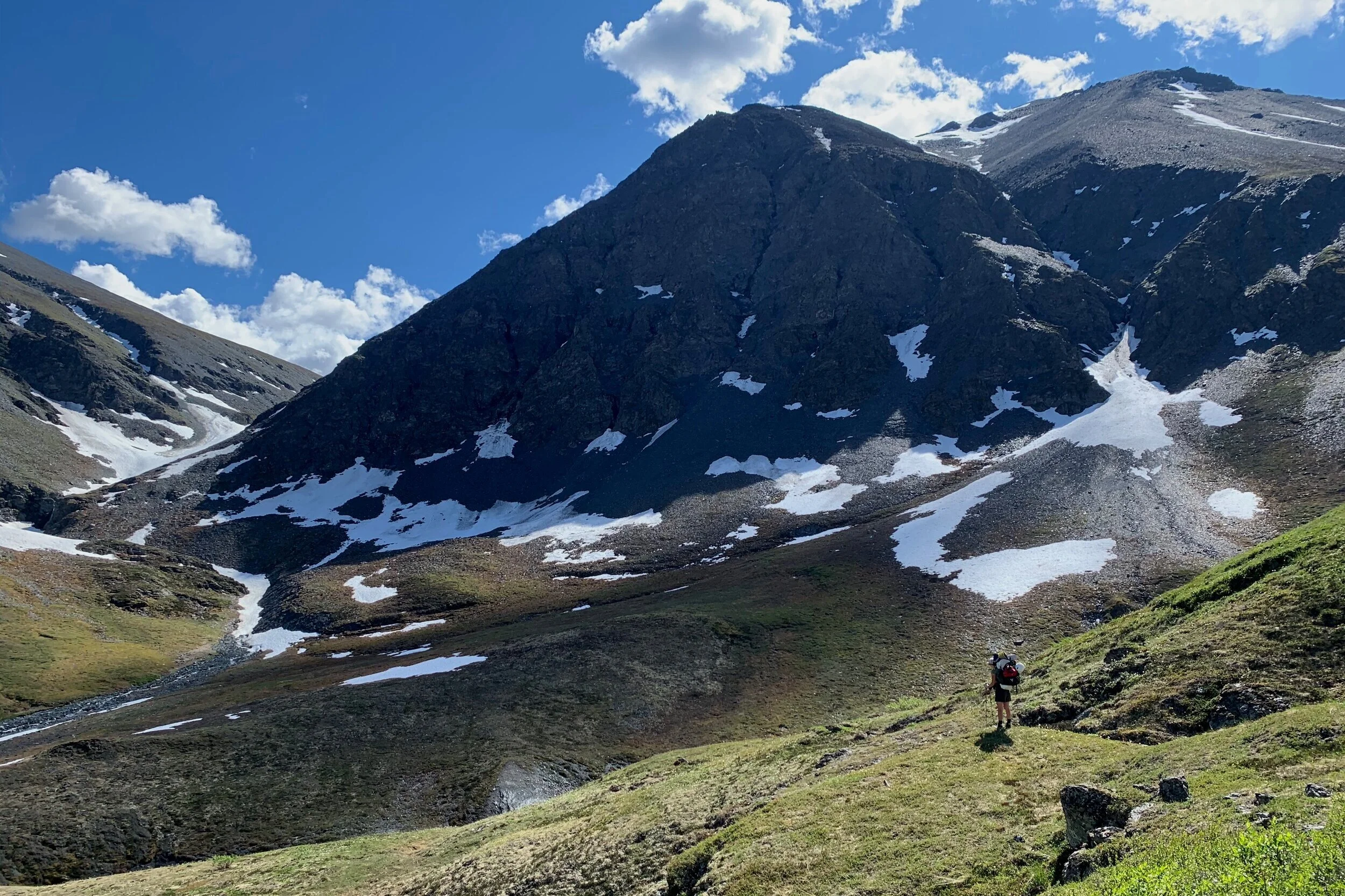
Once we’d passed the wolverines, we found a stunning campsite between two lakes just west of Kinnorutin Pass. From here it would be a quick descent down Amawk Creek to the North Fork of the Koyukuk, which would be a great route if you were more pressed for time. But I had my heart set on visiting Marshall Lake on the backside of Mt. Doonerak, so the next day we continued south and west. I hoped to climb over the northern shoulder of Midnight Mountain - cool name, right? - but lingering snow of questionable firmness and an imminent thunderstorm conspired to reroute us an additional 6 miles down St. Patricks creek to access a mellower pass on the south side of Midnight Mountain. See, Alaska teaches us to always have that plan-B, and also maybe a plan-C, D and E.
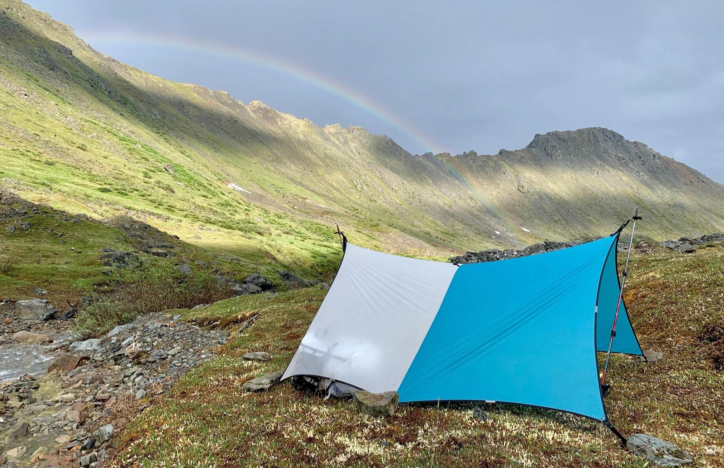
A rainbow at our campsite below Midnight Mountain. We were super lucky to only have rain at night or while in drysuits - we never touched our raingear while hiking.
We camped just south of Midnight Mountain before crossing that snow-covered pass to drop into the Marshall Lake valley. If you look at Marshall Lake on a topo map, you might notice that the descent from Marshall Lake into the Bombardment Creek Valley looks rather steep - the 100 foot contour lines almost touch. And if you checked out the zone on satellite imagery, it would probably look like a cliff. And you wouldn’t be wrong. Going into the trip, I thought this would be the crux, and the consequences of it not “going” would be a demoralizingly brushy reroute. But fortunately, as we came to the edge of the valley and the world dropped away beneath our feet, we spied a tiny sheep trail through the cliffs to our right. We figured if sheep did it, we probably could too. We made it down, carefully, full of gratitude that the rock was dry and the visibility was good. Midway down the valley was another crux-y descent down stair-stepped tundra benches. Until we were on the very last bench, it wasn’t clear if they were continuous, which would have stranded us in the valley with the North Fork of the Koyukuk tantalizingly within our sights. Jaime and I both felt a big rush of relief when we finally stepped out onto the bank of the North Fork; a morning full of anxiety and uncertainty dissolved into a feeling of success.


We camped three nights along the river, the first night directly between Frigid Crag and Boreal Mountain - the actual “Gates” of the arctic - so named by Bob Marshall during his travels in the area. Our campsites were classic arctic river - beautiful, dotted with blooming dwarf fireweed, littered with wolf, moose and bear tracks and quite pleasant with a breeze. When the wind died down, the mosquitos came out in force, making river showers and going to the bathroom fairly unpleasant.
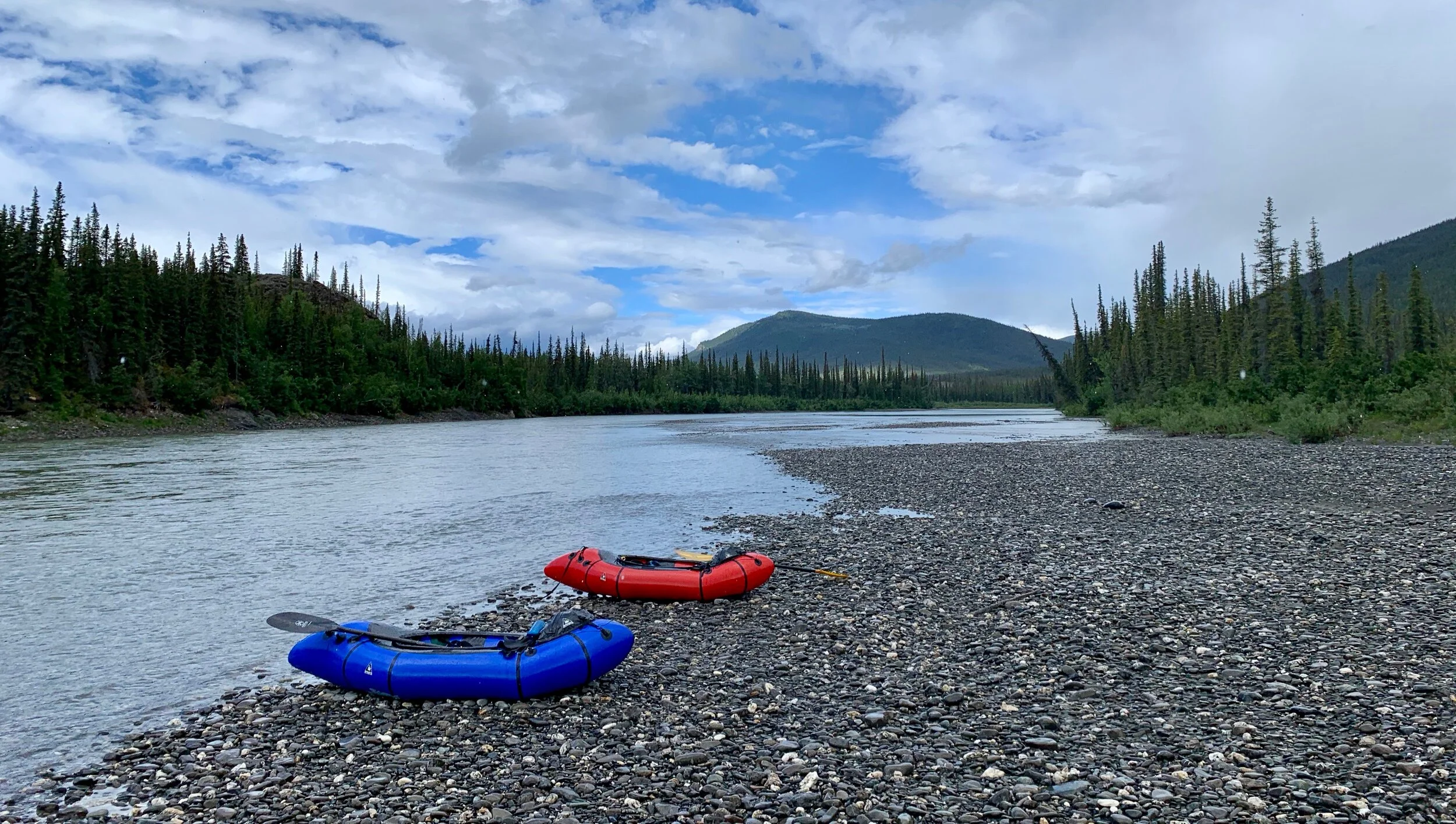

The paddling started splashy and quick-moving, then flattened, but stayed swift. Near the confluence with Cladonia Creek was a notable and fun set of rapids. The splashy wave train made for a brief period of engaging paddling and the limestone walls downstream of Bonanza Creek were a pleasant, scenic surprise. Narrow bands of rain rolled over us while we were paddling, so we often paddled in pouring rain while looking at sunshine or vice versa. Overall, the North Fork of the Koyukuk was low-stress and beautiful. We spied a cow moose with two chestnut colored calves lounging along the river, tons of birds, a very recent (wolf?) killed moose and thousands of critter tracks. I’d say it lived up to its Wild and Scenic designation.
After some debate over where to exit the river, we settled on pulling out at the confluence with the Glacier River, the North Fork bends within two miles of continuous alpine ridge lines that we hoped to link together to return to Coldfoot. We crossed from the North Fork of the Koyukuk to the ridge through spruce forest, mild brush and biblical clouds of mosquitos. But after a steep climb to access the alpine, we were home free for two whole days of ridge walking to within a mile of the Dalton Highway.

Yard sale near the confluence of Glacier River and the North Fork of the Koyukuk.
These two days of hiking in the sunshine along 15+ miles of Brooks Range ridges was my personal highlight. A final descent through heinous alders - thank goodness we were moving downhill - brought us to the Middle Fork of the Koyukuk. After a quick crossing we reunited with our friends at the Marion Creek Campground and headed south. It was such a pleasure to explore another great road-to-road option in Alaska’s Arctic.


I’m happy to be making Covid-lemonade from the weirdness we find ourselves in this year. And I’m so incredibly grateful to live in Alaska, where access to the outdoors and recreation can still be possible, responsible and ethical - even in the middle of a pandemic. I worry a lot about people’s mental health as this crisis drags on. For me, long days of moving through the mountains is the only therapy or counseling I’ve ever known and I know I am so lucky to live in a place where this type of travel is accessible and possible. I hope anyone reading this is happy and healthy, wherever you are. And I hope you have a chance to go outside, move a little and get some fresh air. Be well. 💚
P.S. - If you had the time to read this - hopefully you also have time to write a note to the Kentucky AG Daniel Cameron asking for justice for Breonna Taylor.
P.P.S - And maybe you’d like to support one of the organizations who are suing to stop the Ambler Road - a threat to subsistence, wildlife and Gates of the Arctic National Park where this trip took place.
